UK CAA · CAP 722 · Official NATS data
Everything you need to fly your drone legally in the UK
Ask Maverick — our CAP 722-trained AI — anything: laws, registration, gear, technique. Then check any location on the live map with 1,079 official NATS airspace zones, updated every day.
3,748 drones estimated airborne in the UK right now
1,079
Official NATS airspace zones live on our map
400ft
Absolute legal height limit (120m) for all drones
£11.79
Operator ID annual cost — required for most drones
5 years
Flyer ID validity — the test is completely free
Ask Maverick anything
Live AI · CAP 722Your personal drone expert
Ask absolutely anything — UK law, registration, which drone to buy, camera settings, FPV rules, careers. Try a suggestion below.
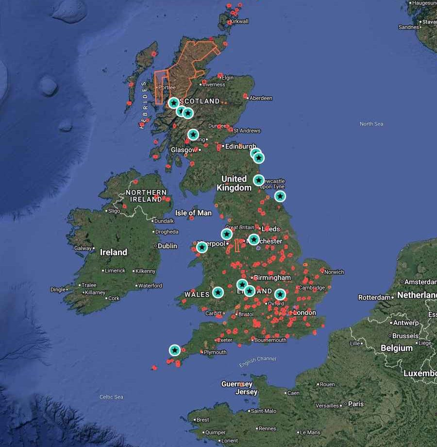
1,079 live NATS zones · FRZs, danger areas & hot spots · updated daily
The Open Category, in full detail
UK drone rules by weight class
Under 250g
A1 / C0 — e.g. DJI Mini series
- Fly over people allowed — but NEVER over open-air crowds or assemblies
- No minimum separation distance from uninvolved people
- Fly in residential, commercial, industrial and recreational areas
- Flyer ID NOT required (unless you want it) — Operator ID IS required if it has a camera and isn't a toy
- Still 100% banned inside airport FRZs and restricted airspace
- Max height 400ft (120m) above ground level, always within visual line of sight
250g – 900g
A2 / C1 — e.g. DJI Air series
- Flyer ID AND Operator ID both legally required
- Never fly over uninvolved people — plan flight paths around them
- Keep 30m horizontal distance from uninvolved people
- 5m separation allowed in low-speed mode with an A2 Certificate of Competence
- A2 CofC theory exam ≈ £100 via CAA-approved providers, valid 5 years
- No flying over crowds under any circumstances
Over 900g – 25kg
A2 CofC / A3 — e.g. Mavic 3, FPV rigs, cine lifts
- Without A2 CofC: fly ONLY in A3 — 150m away from residential, commercial, industrial and recreational areas
- Keep at least 50m from uninvolved people at all times in A3
- 2kg–25kg drones are A3-only in the Open category regardless of certificates
- Commercial work usually needs a GVC (General VLOS Certificate) + Operational Authorisation (~£1,500 all-in)
- Commercial flights require EC 785/2004 compliant insurance
- Over 25kg = Certified category — full aircraft-style regulation
Registration & penalties
Flyer ID, Operator ID and what happens if you break the rules
Flyer ID
FREE- 40-question multiple choice test on the CAA website — pass mark 30
- Valid for 5 years, take it as many times as you like
- Required for anyone flying a drone 250g+ (or any drone in A2)
- No minimum age — children can hold a Flyer ID
Operator ID
£11.79 / year- Required if your drone weighs 250g+ OR has a camera (toys exempt)
- Must be 18 or over to register as an operator
- The Operator ID must be visibly labelled on every drone you own
- One Operator ID covers all your drones — renew annually
Penalties
Up to 5 years prison- Flying unregistered: fines up to £1,000
- Flying in restricted airspace / over crowds: fines from £2,500 upwards
- Endangering an aircraft: UNLIMITED fine and up to 5 years imprisonment
- Police have powers to seize drones and ground pilots on the spot
Know before you launch
Essential facts every UK pilot must know
The 400ft ceiling
120m above ground level is the absolute limit for every drone in the Open category — measured from the ground beneath the drone, so you can follow hillsides upward but never exceed 400ft above the surface.
Airport FRZs
Every protected aerodrome has a Flight Restriction Zone: a 2–2.5 nautical mile cylinder plus 5km × 1km runway protection zones. Flying inside one without Air Traffic Control permission is a criminal offence — even with a 249g drone.
Visual Line of Sight
You must always see your drone with your own eyes (glasses OK, binoculars not). Practical VLOS is roughly 500m horizontally — FPV flying requires a competent observer beside you.
Night flying
Legal in the UK since 2021. The drone should have lit anti-collision lighting, and you must still maintain VLOS — position lights help you keep orientation.
TOAL — Take Off & Landing
Airspace above land is generally free to fly through, but you need the landowner's permission to take off and land. Councils, the National Trust and Royal Parks commonly ban TOAL on their land — launch from public rights of way or permissive land instead.
Danger Areas & HIRTAs
220+ MOD danger areas (live firing, fast jets) and High Intensity Radio Transmission Areas cover the UK. Many are 'active by NOTAM' — check activity before flight. Radio interference can sever your control link above 100ft near HIRTAs.
SSSIs & wildlife
Disturbing protected wildlife with a drone can be an offence under the Wildlife and Countryside Act 1981 — up to £5,000 per offence. Ground-nesting bird season (March–August) is the highest-risk period on moorland and coastal sites.
Insurance
Hobby flying under 20kg needs no insurance by law (though public liability cover such as FPV UK / BMFA membership is smart). ANY commercial flight requires EC 785/2004 compliant insurance — no exceptions.
In-depth guides
Answers to the questions pilots actually ask
 Law
LawThe Complete Guide to UK Drone Laws (2026 Update)
Every rule that governs drone flying in the UK — categories, registration, distances, airspace, class marking, Remote ID and penalties — in one definitive, plain-English guide.
 Locations
Where Can I Fly My Drone in the UK? Every Location Type Explained (2026)
Parks, beaches, cities, national parks, farmland, castles and coastline — the definitive location-by-location guide to legal UK drone flying, with a repeatable method for checking any spot.
 Law
LawCan I Fly a Drone Over Private Property in the UK?
The definitive answer to Britain's most argued-about drone question: what the law actually says about overflight, trespass, take-off rights, privacy and neighbour disputes.
Live drone news
Latest from the drone world
IAA Successfully Prosecutes Drone Pilot for Infringing on Restricted Airspace
Swords and Balbriggan District Court, 08th September 2026   The Irish Aviation Authority (IAA) brought a
Teledyne lands major deal as Europe ramps up drone production
Europe’s push to build more of its own drone capabilities just picked up another sizable industrial commitment. Teledyne Energetics UK, part of Teledyne Technologies, has secured a $15.4 million contract with a Europe-based defense technolo
AirData brings DVR-style rewind to drone live streaming
As drone operations become increasingly remote, it’s not always possible for every decision-maker to be watching a live video feed the moment something important happens. AirData is aiming to solve that problem with a major upgrade to its l
Advanced drone sensors now closer to Canada’s critical industries
Industrial drones have become far more than flying cameras. Today, they’re carrying sophisticated sensors capable of mapping underground utilities, detecting methane leaks, measuring underwater terrain, and even identifying mineral deposits
GA-ASI Unveils Wildfire UAS for Military, Civil and Commercial Role
General Atomics Aeronautical Systems, Inc. has announced its groundbreaking Wildfire UAS, a clean-sheet aircraft designed to maximize future investments in large unmanned aircraft that incorporates lessons learned over decades of large-scal
Drone Show in 9/11 Tribute to World Trade Center Towers Attack
A drone show illuminated the skies over New York Harbor Wednesday night as part of a tribute marking the 25th anniversary of the Sept. 11 terror attacks. The artwork, titled “2,977 Lights Over New York Harbor,” featured 2,977 li
Elbit Systems’ FUSE Integrates Autonomous Air and Ground Systems
Elbit Systems Ltd.‘s FUSE, has unveiled its AI-driven autonomous combat systems and One2Many operational capabilities, enabling centralized real-time coordination of large numbers of autonomous aerial and ground systems. Built on year
AV Gets First International Order for LOCUST Directed Energy Counter‑Drone Systems
AeroVironment, Inc. announced that it has received its first international purchase order for the LOCUST Laser Weapon System. The landmark, first of its kind direct commercial sale (DCS) order, valued at more than $50 million, marks a signi
South Korean Kamikaze Drone Crashes in 4 Seconds During Maritime Tests
The South Korean military conducted a maritime combat experiment in August for a domestically developed kamikaze unmanned aerial vehicle , but both launch attempts failed. Amid drones becoming central to modern warfare, the domestically pro
Regional guides